|
|
[From
Colonial Administration and Social Developments in Middle India: The Central Provinces, 1986-1921. Ph. D. 1980 dissertation by Philip McEldowney]
Part I. The Indian and British Settings
Administrative and Social Regions
[Regions, Sub-regions, and Regionalism]
[The Administrative Region and the Historic Sub-regions]
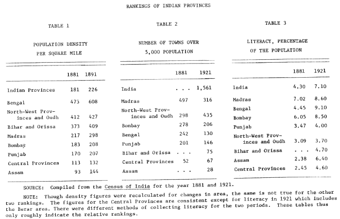
[Tables 1-3. Rankings of Indian Provinces. Population, towns, literacy]
[Table 4. Social Categories in the CP]
[Table 5. CP Population and Cultivated Area]
|
|
When the Central Provinces was created in late 1861, British administrators concentrated their efforts on two major tasks: the consolidation of the area and its development. Just four years before, the British Indian Empire had passed through the most severe challenge of its existence In the aftermath of the Mutiny the imperial structure from the top in London down to the districts in British-ruled territories came under review and reorganization. As part of that reorganization the separate but adjacent British areas of the Saugor and Narbudda Territories and the Nagpur Province were combined to form the new Central Provinces. Each area had separately felt the impact of direct British rule but neither area had achieved all-Indian prominence nor benefitted fully from prolonged British administrative attention. By the creation of the new administrative unit of the Central Provinces, the British hoped to provide the area with the fundamental institutions of efficient and paternal colonial rule, to enlighten the backward people, and to end its isolation from the rest of India and the world. The Central Provinces was one of the latest provinces formed in the British-Indian Empire. British rule had existed for about a century and a half in India's three coastal Presidencies, and more recently in most of the densely populated north Indian plains. Through experimenta- ++Page 6 tion and "patience the British had formulated a package of administrative institutions and procedures, which they believed embodied some of their mat advanced political and economic ideals as set in the Indian environment. During the latter half of the nineteenth century these basic institutions were introduced with little variation throughout the recently acquired areas of central India and in the peripheral territories of Assam, Burma, and the North-West Frontier province. In these areas there was neither time for the leisurely collection of information about the local setting nor the need to repeat administrative experiments, that had resulted in a variety of administrative institutions and procedures. Experience in the older provinces had provided the broad framework and the guidelines within which the processes of consolidation and development could function in the new provinces. For the initial organization of British administration, the Central Provinces was provided with an enthusiastic and energetic Chief Commissioner, Richard Temple. In the preceding fifteen years, Temple had served in what was then the new territory of the Punjab, and had held brief appointments in the central government. He was wall acquainted with the ideals of British rule in India and with the history of administrative experimentation in the older provinces. In the Central Provinces, Temple at once set about the tasks of consolidation and development. The first steps of consolidation and security included a reorganization and redistribution of the army, the police, and the district administrative personnel and units. One of Temple's subordinate officers described some of his initial activities. "Municipalities, dispensaries, primary schools, district boards, dripped from his pen; he created, built, endowed, at up and verified. His energy was awe-inspiring. He want everywhere ++Page 7 and saw everything. (1) In an effort to provide for the future development of the province, Temple proposed schemes to construct railways, roads, bridge , navigation canals; schemes to open up iron and coal mines; and schemes to attract enterprising European ea and coffee planter. to the highlands of central India. After five years of administration, in 1867, Temple moved on to other appointments, as Resident at Hyderabad and then to head the administrations of the older and more important provinces of Bengal and Bombay. In the Central Provinces, Temple was succeeded by John Henry Morris, who continued the tasks of consolidation and development though with less energy and at a slower pace. Under Morris' long term as Chief Commissioner (thirteen years), the administrative process plodded on; few of the principles of Temple's founding administration were changed though some of his more extravagant schemes such as European colonization and navigational canals for the Godavari river were dropped as impractical. Morris concentrated his efforts to extend Temple's principles, to provide continuity, and to integrate the area. In the last years before his retirement from the Central Provinces and from India, Morris saw the fruition of many of his efforts with the passage of several substantial pieces of legislation. He was especially pleased with the passage of the Land Revenue Act in 1881. It was the result of eight years of discussions and revisions, and it provided the province with a separate legal basis, for the first time, for the formation of land policies and programs. The annual administrative report of 1887, twenty-five years after Temple had been made Chief Commissioner, reviewed a quarter century of ++Page 8 change. In commenting on the extensive construction of railways and roads, the report boasted, Now there is probably no part of the Province . . . where the influence of civilization has not been felt . . . . Sir Richard Temple would now hardly recognize the province which he once knew so well. (2) Summarizing the activities of the year under review, it mentioned, The common people are on the whole well-off . . . . The judicial work of the Province is promptly and efficiently disposed of . . . . The people show themselves law-abiding and peaceful. Education has made decided progress . . . . The people have loyally and efficiently taken considerable share in public business. (3) In conclusion it predicted, That the Central Provinces will continue to advance in material prosperity and in enlightenment the Chief Commissioner entertains no sort of doubts. The rate of progress can hardly be as rapid in the future as in the past, but it cannot fail to be real and steady if the Local Administration is not unduly hampered for want of funds. (4) Such optimistic views of the success of consolidation and development were typical of Administrative Reports; they were penned by the heads of the administration. They tended to present an idealistic picture, and often sought to reinforce a Victorian same of well-being and meaningful achievement. But behind such "evidence" and reports lurked difficult and persistent questions which were either briefly mentioned and slighted, or kept out of public administrative documents altogether. These questions concerned the very processes of consolidation and development under colonial rule. How compatible were the two tasks of consolidation and development? The first tended to establish a secure, stable and static framework for British rule, while the second promised ++Page 9 the benefits of rapid and cumulative change hampered only by periodic crises. How much did the two tasks have in common that enabled them to fulfill the promises of both tasks, by providing institutional flexibility to accommodate change especially during periods of violent fluctuations? With such a few English administrators, how deeply and extensively could the new institutions, derived from the British experience in other parts of India, penetrate the Central Provinces? Which Indian groups or segments of the provincial population would provide the best collaborators in the new colonial enterprise? And who would benefit or profit more than others in the long run? Several references indicate that under the surface the tasks of consolidation and development were proceeding very slowly, if at all. One of Temple's fellow administrators wrote of the stubborn character of the Central Provinces. The country is very backward and he [Temple] is determined to shove it forward; the country resists inertly as long as it can, tumbles back as often as Temple props it up, and when forcibly driven forward runs the wrong way, like a pig going to Cork market. (5) When getting down to specifics, even the 1886-87 Administrative Report conceded that, The Police administration requires much attention and improvement . . . and much indeed remains to be done in the matter of communications. (6) Although the Central Provinces had experienced fifty years of being "shoved forward" by British administrators, a report in 1912 pleaded, ++Page 10 The Province must be allowed to take its place as fully typical of the rest of the Indian Empire and must not be regarded entirely as a backward tract lying outside the lines of progress along which the country as a whole is moving. (7) In spite of this imperative, a brief glance at the census statistics of 1881 and 1921 indicates the Central Provinces had changed little in its relative ranking with other provinces over that forty year period. On the basis of very fundamental characteristics such as population density, the number of towns, and literacy, the province still ranked near the bottom along with other "backward" areas such as Assam, and Bihar and Orissa. Irrespective of the "lines of progress along which the country as a whole" was moving, the Central Provinces consistently retained a relatively low status, and could hardly be considered as average or "fully typical of the rest of the Indian Empire." Though changes occurred in some respects (i.e. population density from 113 to 132 per square mile, the number of towns from 52 to 67, and literacy from about 2.5 percent to around 4.6 percent) the Central Provinces was never able to sustain rapid, cumulative development, or what some have termed "take-off," in order to catch up with the other provinces in British India. Explanations for its gradual improvement, though It failed to advance with regard to its all-India ranking, are neither simple nor immediately evident. At a bare minimum three factors may be considered in the search for an understanding of the processes of consolidation and ++Page 11 |
|
|
|
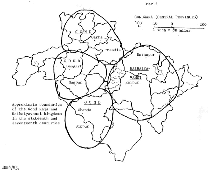
++Page 12 development in the period between 1861 and 1921: 1) its background and characteristics peculiar to the area in the 1860's; ii) the interaction of British and Indian participants and institutions; and iii) the dynamics of events and forces beyond human control. The remainder of this chapter is mainly concerned with the first of these; the others are examined in subsequent chapters. Regions, Sub-regions, and Regionalism Geographically and historically the Central Provinces as created in the 1860's constituted part of a much larger area which separated the two great cultural areas of India, the Aryan north and the Dravidian south. This middle area was an extensive mass of forested uplands interspersed with river valleys and plains, sparsely populated, all of which made political unity and cultural interaction difficult during the pre-British period. The Narbudda river which flowed along the north of the province, historically marked the boundary between northern and southern India. (8) Along each side of the river were the mountain ranges of the Vindhyas and Satpuras. The few military invasions which penetrated the mountain barrier passed through the Burhanpur gap, lying just inside the western border. Even fewer dynasties penetrated into the upland forests of middle India. Nor could the area boast of being the base for wealthy and powerful expansionist dynasties. Rather, portions of the at" became the peripheral and frontier boundaries of imperial dynasties during the Mauryan, Gupta, and Mughal periods. Other small local dynasties ++Page 13 of middle India were at times subordinate allies of the imperial dynasties or succeeded in maintaining an isolated independence. Some of India's religious and cultural developments also spread into middle India, as is indicated by monuments at Sanchi, Ruprath, Arang, and other places. Local sacred centers such as Amarkantak, Mahadeo, and Ramtek, and local religious myths associated with these places in middle India never achieved all-India prominence. Pilgrims from north India passed through eastern Central Provinces on their way to Jaganath at Puri, and merchants transported their goods along the Narbudda trade route down to the port of Bhrigu-Kachcha (modern Broach). The hinterland of middle India formed some of the last political, religious, and economic frontiers for the gradually expanding populations of India. Socially, also, middle India was one of the last frontiers. During the last four or five centuries before British rule, populations from surrounding areas immigrated into middle India, cleared the forest and began to cultivate and develop various areas. These diverse immigrant groups brought with them a variety of institutions and beliefs to add to the already heterogeneous culture. As such, the influx tended to further complicate and weaken any concept of larger regional identity for middle India. The peculiar pattern of British expansion into India in the eighteenth and nineteenth centuries was related to the broad geographic and cultural variations of the sub-continent. This influenced British penetration of middle India. By the 1860's direct rule predominated in the most productive and densely populated areas of India, while indirect ++Page 14 rule existed primarily in the sparse hinterland territories. Although the Central Provinces came under the system of direct rule, much of the rest of middle India came under indirect rule. The Central Provinces was almost an island encircled by a sea of "native States" such as Bhopal and Rewa to the north, Chore Nagpur and Kalahandi to the east, and the Nizam's territories of Hyderabad and Barer to the south and west. Even within the Central Provinces, one-fourth of the area was pockets of indirect administration-"Feudatory States" and "Zamindari" estates-in which local Indian chiefs retained much of their power and prestige. Many of these areas, such as Buster and Fingeshwar, as well as Native States on its border, consisted of forested plateaus with sparse populations. The borders of the province barely touched on other British provinces at four places. Administratively the Central Provinces thus became an intermediate link in the center of the directly ruled provinces of Bombay, Madras, Bengal, and the North-West Provinces and Oudh. But largely, the Native States buffered the province from the rest of British India and somewhat isolated the province administratively. The Central Provinces exhibited considerable diversity within its boundaries. To some administrators the diversity of the countryside we a welcome relief from the uniformity of other parts of India. One wrote, During the next fourteen years the Central Provinces became my home They were in extraordinary contrast with the provinces I had left . Instead of the flat alluvial Ganges plain-a sea of crops during eight months of the year, and the rest a -scorched desert-the. were always forested hills, and even mountains, on the horizon or round one. (9) ++Page 15 On the other hand, this diversity almost caused Temple to abandon his efforts to portray the main characteristics of the province in his first Administrative Report. The country . . . possesses physical and external features so numerous and varied, that to describe them all . . . would be impossible. But I shall attempt such a description. (10) Geographically the wide Satpura plateau was bordered by more productive river valleys. Each area was noted for its different crops: wheat predominated in the northern Narbudda valley, juar and cotton in the southern Nagpur plain, and rice in the eastern Chhattisgarh plain. Even greater diversity was found in the intermediate forest plateau. There some of the people lived by cultivating patches of valley land near the headwaters of rivers; others practiced shifting cultivation combined with hunting in the dense forests; while a third group grazed cattle on the savannah tracts. Linguistically the population spoke mainly Hindi in the north and Marathi in the south, though a few scattered groups spoke Urdu, Monde and Dravidian languages. Similarly the ethnic character of the people was diverse, for the recent immigrants in the area included north Indian, Maratha, and Darvidian castes who settled amidst the local tribal population. The Central Provinces was, in fact, a microcosm of the larger south Asian sub-continent. Both were heterogeneous territories whose peoples were divided by geography, ideology, and organization into many smaller societies. The studies of 0. H. K. Spate and Bernard S. Cohn give evidence of the difficulty of defining the Central Provinces ++Page 16 or dividing it into precise and acceptable sub-regions. In Spate's regional geography of India and Pakistan, the Central Provinces area is split into six regions: in the north, the "central Vindhya Country;" in the middle, the "Satpura-Maikal" region and the "Mahanadi Basin;" in the southwest the "Maharashtra" region; and in the northeast "Chotta-Nagpur." (11) Spate's sub-regions relate particularly to the river valleys: The Wardha valley of Maharashtra, the Narbadda-Son furrow within the central Vindhya Country, and Chhattisgarh within the Mahanadi Basin. In Cohn's analysis of historical regions, parts of the Central Provinces fall into one or another of his different categories: the Narbadda, Tapti, and Godavari river valleys form major agricultural areas or "nuclear" historical regions. The western and northern parts of the Central Provinces lay adjacent to the "shatter zone" at mute area of Malwa. The Chhattisgarh plain of eastern Central Provinces is a "cul de sac," or region of relative isolation. His definition of a "march or frontier region" is most applicable to those "zones or regions between plains and hills, in which the plain's Hindus are extending their political, economic and cultural control over the hill peoples." (12) The spread of Hinduism among hill tribes was described by many people, such as James Forsyth when he toured the hill area of the province in 1862-64 and found groups who had accepted Hinduism. This was also noted ++Page 17 |
|
|
++Page 18 by a Chhattisgarh settlement officer who wrote in the late 1920's that the tribal "Kanwars and Gonds . . . are almost completely Hinduised." (13) The extremes in social and cultural characteristics of the province did not show strong evidences of interchange between areas within the province or the complete breaking down of distinction.. This left the province without a cohesion and larger identity often found in other geographic regions. Immigrant groups often retained affinities with their original homelands and though Hindus settled and lived among tribals, no particular recognizable form of regional culture emerged. The Central Provinces does not fit precisely a definition of a "region," in the war accepted meaning of the tem. The clearest coherent units, rather, are four sub-regions in the province. The Administrative Region and the Historic Sub-regions Administrative units of nineteenth century colonial India rarely coincided with cultural regions and in me way this was truer for the Central Provinces than for other British provinces. Whereas war provinces contained one or two core-culture regions, such as Tamilnadu in Madras and Maharashtra in Bombay, the Central Provinces contained only minor ones. There was, however, precedence to form these into a single administrative unit as historically both the Good Raja and Maratha dynasties had ruled over war of what became the Central Provinces. ++Page 19 Of the two, Good Raja rule had been less unified in spite of the fact that it was more indigenous than the Maratha Bhonslas. This is indicated by a close examination of the two dynasties before the 1860's. Gond Raja dynasties were founded at three centers in the provincial area during the fourteenth and fifteenth centuries and maintained a relatively independent existence until the middle of the eighteenth century. At no time did they unify Gondwana, or the land of the Gonds. under a single Good king, though they and most of their subjects shared common ethnic origins. (14) The Garha-Mandla kingdom in the north extended control over most of the upper Narbadda valley and the adjacent forest areas. The Deogarh-Nagpur kingdom dominated most of the upper Wainganga valley, while Chanda-Sirpur in the south consisted of territory around the confluences of the Wardha and Wainganga with the Penganga. At the height of its power the Garha-Mandla kingdom included the Central Provinces districts of Jabalpur, Mandla, Narsinghpur, Saugor, Damoh, and parts of Balaghat, Seoni, and Hoshangabad; the Deogarh kingdom included Chhindwara, Nagpur, Wardha and parts of Hoshangabad, Betul, Seoni and Bhandara districts; while Chanda included that district and parts of Bhandara. Each of these Gond Raja kingdom separately passed through three successive stages: the first one of comparatively peaceful expansion and consolidation; the second of contact with Mughal emperors or their subordinates and nominal allegiance to the Mughal Empire; and the third ++Page 20 |
|
|
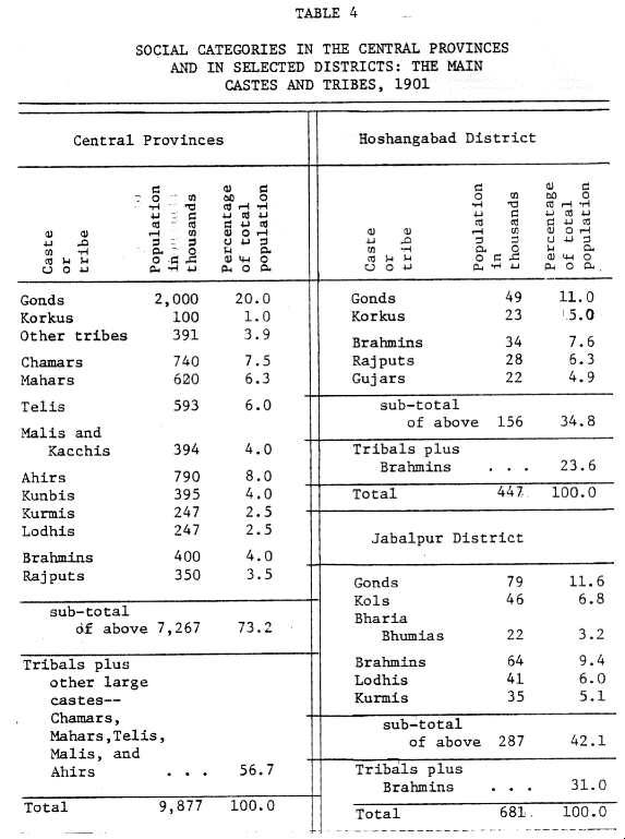
++Page 21 of internal dynastic struggles which eventually resulted in Maratha intervention. In Garha-Mandla, for example, Sangram Shah of the late fifteenth century was renowned both for enlarging his kingdom and encouraging the peaceful settlement of the upper Narbadda valley. In the mid-sixteenth century, Sangram Shah's daughter-in-law, Queen Durgavati, organized a courageous resistance against the invading Mughals under general Asaf Khan. The story of her efforts, and her final defeat and death are still recounted as an important part of local folklore. (15) Though regular ties with Delhi were established and Garha-Mandla retained as a Jagir for the remainder of the sixteenth century, in the beginning of the seventeenth century, Delhi returned half of the territory to the management of the Garha-Mandla Rajas, presenting the other half to the Gond Rajas of Deogarh. During the middle of the seventeenth century Raja Hirda Shah paid his respects to the Delhi court and was praised for his wise and peaceful reign. (16) A dispute between claimants to the throne brought temporary Maratha intervention in 1732. From 1742 onward, the Marathas demanded a regular heavy tribute, but the governors of Saugor, known as the Maratha Pandits, did not annex the kingdom until 1780. The head of the Maratha confederacy, the Peshwas, awarded the territory to his Maratha allies, the Bhonslas, in 1791. At about the same time both Deogath and Chanda passed through similar military, political, and administrative changes. Muslim contact and ++Page 22 control was almost as superficial at the center and the south as it was in Garha-Mandla, though there it had entered from the west instead of the north. In the early eighteenth century Bakht Buland of Deogarh visited Delhi and was converted to Islam. He returned with Muslim craftsmen. However he did not attempt to convert his subjects nor discard many Good Raja customs. It was he who moved his capital from the plateau down to Nagpur on the plains. Little did he realize the significance of this move . The site soon became the capital of the Bhonslas and eventually became the focal point of administration under the British in Central Provinces. Border territories on the extreme wings of the Central Provinces remained outside the Good Raja kingdoms and came under very different influences. In the northwest, the area, which became the districts of Nimar and Hoshangabad, was open to the influences and the events of Malwa and Khandesh, while in the southeast, Chhattisgarh continued an isolated and independent existence under a local dynasty. In the northwest, the Narbadda valley towns of Burhanpur in Nimar district and Handia in Hoshangabad district lay on the main road between north India and the Deccan. At various times before and during Mughal rule Burhanpur became the headquarters of Muslim administration for neighboring areas and over the Deccan. Hoshangabad district became the center of territorial disputes between the Bhopal rulers, the Maratha Peshwas, Holkar, Scindhia, the Bhonslas, and local chiefs. The Bhonslas eventually dominated most of the district and signed it over to the British in the treaties of 1817-18. In the east, the founding of the Rajput Haihaiyavansi dynasty in ++Page 23 the nuclear area of the upper Mahanadi valley predated the rise of Good Raja rule by several centuries. The dynasty originated as the eastern province of the tenth century Kalachuri or Chedi kingdom. They ruled from a capital at Tewar near modern Jabalpur. By the eleventh century a branch of the Chedis had settled in Chhattisgarh and in the twelfth century became independent. Soon after, when the Chedi dynasty fell, all administrative and dynastic ties were lost between the upper river valleys of the Narbadda and Mahanadi. For over six centuries Chhattisgarh remained under the loose control of the Haihaiyavansi rajas, neither expanding into neighboring regions nor succumbing to invasions. (17) Their kingdom included the Central Provinces districts of Bilaspur, Raipur and most of Sambalpur. Two events occurred during this time. In the late fourteenth century dynastic control divided between a northern, older branch at Ratanpur (Bilaspur district) and the younger Raipur branch in the south. In the middle of the sixteenth century the Ratanpur raja visited the Delhi court. But Chhattisgarh was so far removed from the invasion route between north and south India, it hardly felt any of the Muslim influence which the Good Rajas experienced. The Haihaiyavansi rule in Chhattisgarh came to an end in the middle of the eighteenth somewhat by geographic accident, for the Chhattisgarh plain lay directly on the route between the Nagpur base of the expansionist Maratha Bhonslas and the wealthy coastal plains of Orissa and Bengal ++Page 24 which they wished and attempted to conquer. In contrast to the Haihaiyavansi rule which endured for more than six cen tries and the indigenous Gond Raja dynastic period which lasted more than three centuries, the Marathas ruled their areas for less than a century. They reached the zenith of their power during the last years of the eighteenth century, during which time they extended their rule over the fading Good Raja kingdoms, Chhattisgarh and parts of eastern India. The general growth of the Maratha empire had its beginning in the early eighteenth century when the Maratha Bhonsla family established their right to collect taxes in Barer country, just west of the Nagpur plain. Twice, in 1734 and in 1743, the Nagpur Good Rajas appealed to the Bhonslas to intervene in succession disputes. The second time the Bhonslas took over Nagpur and made it their capital and base for further expansion. During the middle decades of the eighteenth century, Bhonsla armies marched east through Chhattisgarh on their way to raid the east coast and Bengal. In 1741 the Chhattisgarh capital fell but firm control over the eastern Central Provinces area was not established until 1744. In the north the Maratha Peshwa armies successively pushed up the Narbadda valley defeating local rulers, such as the Nawab of Bhopal, and replacing them with governors, like the Maratha Pundits of Bangor. From the late eighteenth century until the defeat by the British in 1817, the Bhonslas managed the Narbadda valley. Here, as in Chhattisgarh, the population remained non-Maratha. Only around their recently acquired home territory of Nagpur was the majority of the population Maratha in origin. ++Page 25 Soon after the turn of the century the Bhonsla fortunes began to change. In 1803 they suffered a serious defeat by the British and their kingdom's wealth was drastically reduced. In their army the 18,000 cavalry was considerably cut, 25,000 infantry were never replaced, and almost half of the artillery was lost. (18) The British stripped the Bhonslas of their east coast territories, part of Sambalpur, as well as their income from Barer taxes, so only a little more than half of their former annual revenue remained. In an attempt to recover their losses they increased taxes in the remaining areas and collected as fully as possible, even by violent means. Militarily limited by the treaties, they, like the rest of the Maratha confederacy, could no longer exercise control over their lowest ranked troops, the Pindaris. Between 1806 and 1816 Pindari bands annually left their bases in the central high-lands north of Nimar, and made extensive raids for pillage and extortion of wealth. The Narbadda valley especially felt the brunt of their activities. (19) Incensed by the disorder for which they were indirectly responsible, the British decided to temporarily abandon their policy of non-intervention. in central Indian affairs. Between 1816 and 1818 British troop. pursued and dispersed the Pindaris. They used the largest number of troops (120,000) ever concentrated before in one locality against the 30,000 Pindaris. ++Page 26 About the same time, a new claimant to the Bhonsla throne, Appa Sahib, came into open conflict with the British. He was defeated at Nagpur but escaped for a few years into the protection of some of the highland Gond Raja chiefs. A few of the Bhonsla governors, such as Chimna Patel of Lanji, on the eastern Nagpur plain, loyally followed the Bhonsla claimant's example of resistance but they were overwhelmed by British forces. (20) Elsehere, around Chanda in the south, a rebellion of Good chiefs had devastating results. Chanda had been a prosperous cotton trading town in 1803 with about 5000 houses. By 1818 only 2800 remained. (21) In eastern Chhattisgarh a tribal chief, Ram Rai, attempted to establish a small independent estate. (22) This also called for British "pacification" forces. By 1818 these pockets of resistence were subdued and there followed a decade without further violence. The British consolidated their position in the north by forming a new province of the Bangor and Narbadda Territories and put it under the control of an Agent of the Governor-General. They divided the remaining Bhonsla territory into four large districts. During the minority of the Bhonsla. prince, from 1818 to 1828, the Nagpur British Resident ruled these districts through British superintendents. In both the new province and the Bhonsla. districts the British attempted to ++Page 27 raise taxes to the abnormally high level of the preceding Bhonsla Raja, with sometimes unfortunate results. A British official in the 1860's looked back to this tax settlement of 1821 in the Hoshangabad district and spoke of it as "the worst settlement every made." it had been made when the British officer, had to deal with a depopulated country and an impoverished and dispirited people, whose ties to the villages they inhabited had been loosened by fifteen year of suffering and oppression. He probably was one of those sanguine man who held the opinion . . . that the benefits of peace and security conferred by our rule would at once commend themselves to native feeling, and would attract capital and population, so as to cause a complete revolution in the state of things then existing. This was one of those tremendous mistakes, the effects of which many years of subsequent moderation and justice have hardly been able to wipe away. (23) A special inquiry into the condition of the Saugor and Narbadda Territories was finally made in 1834. It confirmed that the heavy British taxation had produced a British administration characterized by "an extensive system of fraud and peculation." (24) Reforms followed; the taxation was reduced and new laws of civil justice were enforced. Already the advent of British rule in the Territories had resulted in the abolition of practices which were the most repugnant to British administrators. Both the public sale of widows and sati were prohibited. In the 1830's a campaign to suppress murderous gangs called thugs was begun. Almost a thousand were hanged and their relatives and agents (informers) were imprisoned in a concentration camp at Jabalpur where ++Page 28 [their decedents were] taught to manufacture tents and rugs. (25) Some of the new laws and procedures of British justice did not find immediate approval or total acceptance. In 1842 two landlords in the Territories refused to obey a court order to pay tax arrears or haw their land confiscated. Other near-by landlords followed their example and took up arms against the British, For more,than a year British forces failed to supress this rebellion, known as the Bundela Uprising. (26) So, too, in Chhattisgarh in 1856 a local landlord, Narayan Singh, unlawfully removed grain from a merchant's shop to provide his cultivators with seed grain. Earlier, in 1819, his father, Ram Rai, had resisted British "pacification." Though Narayan Singh immediately informed British authorities of his action and his reason forit, he was imprisoned. From his marmed position in the Raipur jail, he became a public symbol of unjust British laws which fired further revolt and resistance in 1857. (27) Bhonsla rule over Nagpur and Chhattisgarh had ended inauspiciously In 1854, as the Maratha kingdom lapsed to the British for lack of a recognized legitimate heir. But the old administrative units of the Gond Rajas and Bhonslas were not unified under a single British province for another seven years. During these intervening years the area came under the influence of the wider Indian revolt of 1857, followed by ++Page 29 the final stages of "pacification" in central India. During the revolt, Indiana in British military units in north India mutinied, receiving support and assistance from landlords. The strongest center of resistance in the Central Provinces area was in the neighborhood of the Bundela Uprising of fifteen years earlier. In Chhattisgarh, Narayan Singh escaped from jail, collected troops and fortified his village. When the British arrived, he retreated, and they burned the village to the ground. Though he surrendered the next day (2 December 1857) without fighting, he was soon tried at Raipur and eighteen days later publicly executed by being "blown from a gun." (28) A little more than a month after this, seventeen Indiana who mutined were also publicly executed by hanging. (29) At Jabalpur the Good Raja family, who were the last surviving descendants of the Garha-Mandla dynasty, prepared to revolt against the British. Their plans were discovered and both' the father, Shankar Shah, and his son, Raghunath Shah, were blown from guns. (30) In rebellion against the British, Sarju Prasad, the ruler of Bijeragogarh (just north of Jabalpur district), killed his British appointed minister and maintained independent control of his petty state for over a year. He eluded capture until 1864, when he was sentenced to life imprisonment; but on his way to prison he committed suicide at Benaras. The British ++Page 30 confiscated his state and attached it to the reconstructed Jabalpur district. They provided a small pension for his son. (31) Military operations dispersed most of the mutimers by the end of 1858. After six decades of their initial intervention the British finally brought the Central Provinces area under their control. The administrative boundaries of the Good Raja kingdom and the Maratha Bhonsla territories formed a precedence for making the Central Provinces an administrative unit. But the five or six centuries of administrative and political history preceding the formation of the Central Provinces also indicate the persistence of separate subregional political networks and the superficial nature of a larger regional unity. Neither the Good Rajas nor the Bhonslas were ever able to develop and provide the unifying sumbols, ideologies and institutions which might have overcome geographic, ethnic, linguistic, and cultural sub-divisions. The underlying ethnic and even cultural unity of Gondwana. was never combined into a larger political unit by the separate Gond Rajas. Even though the Maratha Bhonslas spread a single administrative system over a large area of central India, as heirs to the Good Raja and Haihaiyavansi kingdoms, their rule was comparatively short and they were foreigners except in their base area around Nagpur. In 1861 the British in turn became the heirs to the larger administrative entity of the Gond Rajas and the Bhonslas and intended to introduce a single administrative system. The Social Frontier Besides the administrative history, the social history of the Central Provinces area indicates strong sub-regional ties. The original diversity of a sparse population and the inflow of other groups into this social frontier produced even greater diversity during the five centuries before British rule. Three characteristics are striking about the origins of the diverse population found in the Central Provinces by 1861. First, for many their arrival in the province was relatively recent, during the last two dynastic periods. Second, they had not come from my me area nor even from me direction, but from all surrounding areas and some of them from long distances. Third, the process of immigration occurred in waves or at peak periods which generally coincided with invasions or upheavals in adjacent territories, or to add support to ruling princes, or for trade, or similar reasons. Many invaders and migrants found themselves in favored situations among the relatively backward people. This diversity of its population and its causes contrasted to characteristics of society found in many other parts of India. In the densely-cultivated areas of northern India, the majority of the population had often resided them for many centuries and any traces of immigration had been obscured by time. When there were shifts in popu~ lation it was largely when the migrants occupied lands adjacent to the parent village. Long-distant migrants who had arrived in the last six centuries formed only a small percentage of the population. Originally they had come from a single direction, either further up the Ganges plain or from the northwest, Afghanistan and beyond. ++Page 32 Society in the Central Provinces shared one characteristic with other parts of India. The functional unit of society was the jati or sub-caste. The jatis formed competitively mall and localized sub-caste groups, who with other somewhat related groups made up the classical but non-functional divisions of society or varnas. (32) While the process of social interaction and circulation had been structured in northern India for several centuries, in the Central Provinces, because of is, migration and the slow proccess of stabilization, jatis had to establish their position initially, then settle into a new pattern of social interaction. Compared to north India the Central Provinces was a young country and in commenting on the "extreme youth" of the area, one Central Provinces officer remarked: Here the memory reaches a very short way back, and a mall period of time covers as much mental space as many centuries do in the ancient communities of the Doab . . . . A period which would be considered trifling elsewhere appears to be of enormous duration . . . here. (33) Almost any district in the Central Provinces illus trates the nature of the immigration process. Hoshangabad district in northern Central Provinces provides one example. The internal geography of the district consisted of a central, fertile Nerbudda valley running east to west with the Vindhya hills rising sharply to the north and Sutpuras rising gradually in the south. Before the sixteenth century much of the population belonged to tribal groups and various localized castes. These ++Page 33 included the Munda-speaking Korkus, the Dravidian Gonda, Narmadeo (Narbadda) Brahmins and claimants to Rajput and Ahir or Gaoli caste status. Migrants after 1500 came from three directions during three peak periods. From northern Indian and Bundlekhand, immigrants entered and settled in eastern Hoshangbad, while Malwa immigrants entered through Handia in the west. The last ones, from Maharashtra, Khandesh, and Marwar, entered the district by proceeding up the Narbudda valley. The peak immigration periods occurred at the turn of the seventeenth century, during the late seventeenth century, and in the middle of the eighteenth century. These periods roughly corresponded to the time just following the Muslim invasion by Asaf Khan of the Garha-Mandla kingdom, the beginning of Aurangzeb's rule in the Deccan, and the establishment of Maratha rule in Hoshangabad. Each of these events exposed Hoshangabad district to immigration from the outside as illustrated by specific jati histories. Around 1600 the Lehora Gujars migrated from around Gwalior and settled in eastern Hoshangabad district. Three groups trace their origins to the middle immigration period-the Kirars from Dholpur, the Chauria or Deshi Kurmis from Gwalior, and the Raghavansis first from Rajasthan to Gwalior and then to Hoshangabad, All three settled in the eastern and central parts of Hoshangabad district. The third migration period initially saw the arrival of Mundle Gujars and Jats from Marwar, and of Bundlekhand and Pardeshi Kurmis from Bundlekhand and Oudh respectively. The most recent groups included the Deshwalis from Marwar and Khandesh, Bias or Pardeshi Rajputs from Oudh. Tilohia Kurmis from Khandesh and a few Maratha Kunbis. Most of these last groups settled the remaining areas of Hoshangabad district, i.e. the western part of the district and some of the center. In the ++Page 34 western-most tahsil of Hoshangabad district, Mundle Gujars settled southern Harda while Jats chose the northern part. The Pardeshi Kurmis cleared the forests around Itarsi (central Hoshangabad district) and began cultivating the land. (34) Hoshangabad is not atypical of the rest of the Province. An examination of almost any other district reveals similar processes: the recent arrival of several groups, and evidences there were peak periods of immigration that corresponded to political pressures and upheavals within and outside the Central Provinces area. (35) In the Jabalpur district, Sangrani Shah's reign, the Muslim invasion, and the establishment of Maratha rule also appear to have stimulated migration. However, because of its distance from Maharashtra and its closer proximity to northern India, few Maratha groups settled in Jabalpur district; the majority of immigrants came from Bundlekhand and the Ganges plain area, later designated as the North-West Provinces. In contrast to this, the majority of the population around Nagpur consisted of Maratha castes such as Kinbis and Mahars. In addition there was a small sprinkling of Malwa and north Indian castes brought in during Bakht Buland's reign. By the time the Bhonsla Marathas established Nagpur as their base in the early eighteenth century, the surrounding area was already densely populated with Maratha groups. ++Page 34 The Chhattisgath plain appears to have acquired most of its population at an even earlier date than Nagpur and most of the rest of the Central Provinces. Tribals such as the Gonds, Baigas, and Binjhwars, and the low caste Chasers vaguely trace their arrivals to a time prior to 1500. The Raihaiyavansi ruler, Kalyan Sai, in the sixteenth century attracted a few Kanaujia Brahmins to his court. They soon separated from north Indian Brahmins and formed Chhattisgarhi Brahmin jatia. Just before and during the early period of Maratha rule, several north Indian Bania families immigrated into the Chhattisgath area; but both the Brahmin and Bania imigrations were of small numbers of families rather than of larger groups. The Tali and Halba castes of Chhattisgarh are unable to give a specific date for their arrival, though it may have been around or soon after the sixteenth century. The traditions of both castes show confusion over the area of their origins; some tracing it to Orissa, some to the Deccan, while other. point to Maharashtra. In a few areas of the Central Provinces the clearing of forests and the settlement of the country still continued into the nineteenth century. In the southwestern valley of Balaghat district, Powers had Just arrived in the preceeding century. After the 1860's the Central Provinces government induced Powars along with Gonds to clear land, construct irrigation tanks, and cultivate rice in areas above the valley. (36) In addition to the predominat tribal, low caste and cultivating caste population, several smaller castes were attracted to the Central Provinces for government services or to trade as the frontier was con- ++Page 36 quered. Various Brahmin groups and Kayasths provided the min families who obtained positions in different administrations. Bakht Buland appointed the Kayasth ancestor of Dadu Culab Singh of Seoni as army paymaster, while the Garha-Mandla Gond Rajas appointed one of the ancestors of Beohar Raghubir Singh of Jabalpur as their minister. Both families appear originally to have come from northern India. (37) In Nagpur the Chitvavis family, belonging to the Maratha Prabhu caste, sometimes designated as a scribe caste, served the Bhonslas as official secretaries. By the 1860's Maratha Brahmin families over much of the Central Provinces represented the remnants of locally appointed governors and officials under the Bhonslas. These included the Bhuskutte family of Hoshangabad, the Raghunath Rao family of Jablapur, and several families in Chhattisgarh such as the Raghoba Mahadiks of Rajim and the Danis of Raipur. (38) Even after the establishment.of British rule a few families were attracted from the outside to government service in the Central Provinces. Among these were Maratha Brahmin educators from Poona and Bombay, and Calcutta lawyers such as Bepin Krishna Bose. Though a few northern and western Indian banking families immigrated before the Maratha period, it was during the height of the Bhonsla power and afterwards that a large number of Marwar and Khandesh mercantile families established their residences and businesses at the expanding trade and administrative ++Page 37 centers of the province. Even during the British period, mercantile castes continued to push into the area, first during the cotton boom of the 1860's, next with the wheat boom of 1870's and 1880's and finally when the railway opened up the rice plains of Chhattisgarh after the 1880's. This type of immigration is exemplified by the Marwari families of Gokuldas in Jabalpur and Abirchand in Nagpur from Ragisthan, and the Muslim Botha or Kacchi merchants from Gujarat. The expansion of the Central Provinces population by the accumulation of immigrants exhibited several diverse characteristics. Though in many cases the immigrants were the first to occupy new lands, in other cases they settled among people already cultivating valley land.. The immigrants not only extended cultivation to new lands, but also intensified cultivation in others. The quantitative aspect of this immigration process is difficult to determine, as few estimates of population and cultivated areas exist. Except for the cultivated lands immediately adjacent to large rivers, however, the Central Provinces appears to have been sparsely settled even up to the seventh century. The Ain-i-Akbari and other do-nts reported that wild elephants could be obtained in the Hoshangabad and upper Narbudda areas. (39) Two centuries later the British found wild elephants still available, but only in the eastern forests of the province. During a three-year campaign the British captured and tamed the 200 or so remaining wild elephants. Having served its purpose the Khedda department was abolished in the late 1860's. (40) ++Page 38 On the, other hand, when Kurmi Immigrants from the Doab settled in Jabalpur district around the middle of the sixteenth century, they chose the central portion of the district because it "most resembled the broad and open tracts of their fatherland." (41) The area appears to have already been wall cultivated. Such indirect evidence of the pre-British period implies that large forests covered much of the Central Provinces area, enough to support herds of wild elephants. At the same time, some of the Central Provinces was already wall cultivated before the migration occurred. In one respect the population in several districts of the British period appeared homogeneous. Almost half of the population belonged to only a few castes and tribes. In war districts more than a fourth of the population consisted of tribals plus the largest Hindu caste. (See table.) Yet a closer examination of the functional social units, subcastes or jatis, indicates the deceptiveness of this homogeneity. Each tribe consisted of several smaller groups. Most writers described various sections of the Cond tribe, and members of the tribe claimed the traditional twelve and a half sub-division. (42) In Jabalpur at least five ++Page 39 |
++Page 40 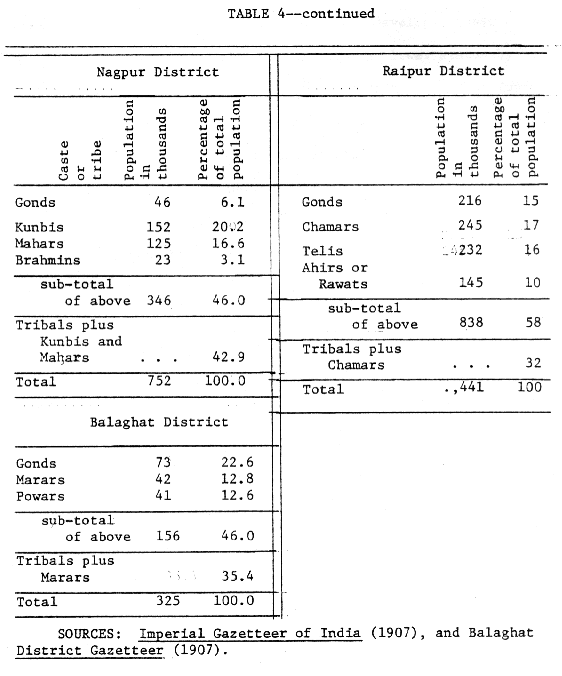
|
|
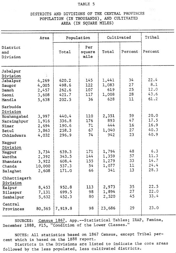
++Page 41 Brahmin sub-castes existed. Telis in Chhattisgarh claimed several subcastes. (43) These sub-divisions were once again related to the migration process. The first arrivals of various castes developed their own groups in isolation. They were usually accorded lower status by later arrivals. As in the case of the Chhattiagarh Brahmins, other Kanaujia Brahmins considered the earlier immigrants had become defiled or debased by their long residence in the wilds, among non-Hindu tribal people. (44) Similarly the designation "Jharia" or "jungli" often identified the earliest Teli, Kurmi, and Kunbi sub-caste immigrants. This indicates, then, that even though various groups immigrated at differ times from the same area to the same district of Central Provinces, their social status was determined by the length of their residence in the province. As indicated previously, immigration did not end with the advent of British rule in the nineteenth century, but when compared to the previous 500 years, it was negligible. The immigration that did continue was usually of specific types. Small numbers of both merchants and government officials continued to arrive. Migration similar to that of the Ganges plain, over short distances, continued within Central Provinces as farmers took up lands in the sparsely populated areas. In addition, seasonal migration of agricultural laborers as had developed in the decades before the 1860's continued. At one point in the 1870's British administrators became alarmed by this type of migration. One ++Page 42 newspaper reported that large numbers of persons were migrating westw::d from th Bhandara, Balaghat and Chanda districts into Berar. The art suggested that this was due to the administration's heavy taxation and harsh rule. Upon investigation, the matter was clarified by both the Central Provinces and Barer governments. The migration was found to be an established pattern of seasonal laborers going to Berar to earn wages in the cotton harvest there. (45) Clearly by the end of the nineteenth century, the characteristics of population movements in the Central Provinces corresponded more closely to that in other parts of India, even though this was a comparatively recent stabilization of the population. During the previous six centuries a large part of the population had arrived from outside the area. These settlers in this social and economic frontier brought with them varying ideas of social structure and organization. Although many of them lost contact with their original homeland and formed new jatis, they generally reduplicated their past structural patterns of social relationships in the new setting of the Central Provinces. These multiple patterns and traditions of the migrants added to the already diverse characteristics of the population which had existed in 1500 or before. The Administrative Region after 1861 The Central Provinces emerged in the 1860's as a product of the administrative inheritance from the Gond Rajas and the Maratha Bhonslas, ++Page 43 and of the social inheritance from the gradual accumulation of an immigrant population from a variety of Indian areas. After 1861 many policies of the new British administration tended to integrate both the administrative region and its sub-regions, while the recognition of Narathi and Hindi as official languages in their respective areas, and the development of railways placed emphasis on differences. Twice in the late nineteenth century the Government of India questioned the wisdom and necessity of maintaining the Central Provinces as an administrative unit. Both times British administrators in the province successfully fought off the challenge. Then in the twentieth century significant boundary changes produced new configurations of the adinistrative unit. The most enduring administrative units throughout the period were those of the separate and relatively small districts, and the four "Division." From the beginning the administration organized the nineteen districts of the Central Provinces into four divisions, which generally coincided with previously administered sub-regions. The Jabalpur division in the north centered around the upper Narbudda valley and the old GarhaHandle kingdom, It included the Saugor, Damoh, Jabalpur, Mandla and Seoni districts. The Narbudda division in the middle Narbudda valley with its headquarters at Hoshangabad, covered the five districts of Narsinghpur, Hoshangabad, Nimar, Betul and Chhindwara. The Nagpur division consisted of the Maratha districts of Nagpur, Wardha, Bhandara, Chanda and Balaghat. Raipur, Bilaspur, and Sambalpur districts formed the fourth division of Chhattisgarh with its headquarters at Raipur. Added to these districts was a small, separate unit in the extreme ++Page 44 |
|
|
|
++Page 47 Estates. (46) The rulers of those fifteen areas, though subject to defined agreements for British supervision, would remain managers of their estates. The largest Feudatory State, Bastar in the south, contained 13,000 squares miles. The remaining 15, 000 square miles surrounded Chhattisgarh and separated Chhattisgarh division from the Nagpur and Jabalpur divisions. The encirclement of Chhattisgarh by these areas isolated it and isolation remained one of the division's historical characteristics. Though in the late nineteenth century the administration tried to bring the Zamindari areas under closer British supervision, the rulers legally resisted. When the issue was brought before the English Privy Council in the early twentieth century, the Central Provinces administration failed to obtain a clear decision, which would allow a closer integration of the Zamindari areas with the directly administered districts. (47) The Feudatory and Zamindari states of the province continued to block the development of broader provincial integration under British rule in the same way that Native States continued to present integrative problems elsewhere in India. The government's official position on languages for the Central Provinces led to controversy. The official languages used by British provincial governments were Persian and Urdu. From Mughal times they had persisted in the courts, and a group of Indian officials had developed a vested interest in their continued usage. Persian and Urdu were used ++Page 48 in the Saugor and Narbudda Territories and before the 1860's had been introduced into the Maratha Bhonsla government and the Nagpur Province. Several efforts to introduce Hindi add its Devanagri script into northern Central Provinces after 1835 failed. In the 1860's one of the first concerns of the Central Province administration was to introduce Marathi, instead of Persian and Urdu, into the Nagpur division. As one of the Chief Commissioners declared: The adoption of a foreign tongue (Urdu) in the Courts of Justice is unavoidably unpopular and it leads to the almost exclusive employment of Hindustani ministerial officials, who are foreigners to the natives of Nagpur . . . . Marathi should be declared by Government to be the Court language in the four districts of Nagpur, Bhandara, Chanda and Wardha. (48) Marathi became the official language of Nagpur division in 1865, but Urdu remained the language in the north. The introduction of Marathi soon caused problems. Many of the English administrators in the division did not know Marathi and thus could not understand most of the government correspondence carried on in their own offices. A Chief Commissioner recommended that Central Provinces civil servants be grouped into two linguistic units. British administrators in northern Central Provinces would continue to learn Urdu and be recruited mainly from the north Indian civil service, while those in the southern Central Provinces would be recruited from Bombay and learn only Marathi. The Government of India opposed such a proposal and instructed the Central Provinces government that their officers should become proficient in both languages. (49) ++Page 49 The entire issue of official languages for the Central Provinces was not finally decided until 1871, after an Indian group from Jabalpur petitioned the government in favor of Hindi, instead of Urdu. The Chief Commissioner agreed that the official language should be "the language of the people." Both the petitioners and the Chief Commissioner presented statistics which showed that Hindi was definitely the popular language of the northern province. A few British officials opposed Hindi, describing it as an "inferior tongue." But the Chief Commissioner concluded that "two great errors" had been made by previous administrations. First, mere official convenience was consulted, instead of keeping to the broad principle that we should recognize but two official languages--the language of the governing nation (English) and the language of the people; and, second, we did not apprehend the strong affection felt for the Hindi language by the mass, and believed erroneously that by perservering in the use of Urdu we could naturalize it. The Chief Commissioner's forecast proved correct, though the decision produced much stronger controversy there than in the Central Provinces. The policy decisions of the administration in the 1860's and 1870's concerning official languages ensured that local government proceedings would be carried on in a language which most of the population understood. Those decisions re-emphasized the cultural division between northern and southern Central Provinces. ++Page 50 The improvement of communications, especially the railways, also emphasized this northern and southern division of the provinces. In 1867 railway lines were completed between Nagpur and Bombay in the south and between Jabalpur and Allababad in the north. Mail continued to be carried by tonga (a one-horse carriage with two wheels) along the road over the Satpura plateau between Jabalpur and Nagpur until 1870. In that year the railway line between Jabalpur and Bombay was completed. The Bombay lines to Jabalpur and Nagpur divided at Bhusawal just west of the Central Provinces border. No direct railway link between the north and south over the Satpura plateau was constructed until the twentieth century. Until then the journey, and the mail, between Nagpur and Jabalpur took almost tweuty-six hours, or about the same time necessary to travel to Bombay from either of the two largest cities in the Central Provinces by rail. Chhattisgarh remained the last subregion to be brought into railway communication with the rest of the province. Between 1888 and 1892, however, railways were completed in almost all directions from Chhattisgarh-west to Nagpur and then beyond to Bombay, east to Calcutta, and north to Jabalpur and the Ganges plain beyond. Thus by the early 1890's the two tran-Indis, lines between Bombay and Calcutta lay within the Central Provinces, the northern one passing through the Narbudda and Jabalpur divisions, and the southern one passing through the Nagpur and Chhattisgarh divisions. Until the end of the second decade of the twentieth century, the Satpura plateau continued as a geographic barrier and hindered transportation and communication between northern and southern Central Provinces. ++Page 51 The steps taken by the Central Provinces administration to organize the province into two linguistic areas, recognizing Marathi as the official language in one and Hindi in the other, and parallel developments of railways in both areas made for a farm of integration in diversity. But the Central Provinces administration soon faced a challenge to those integration efforts from officials outside the province. In the early 1870's the Government of India proposed that the Central Provinces should be divided and parceled out to the Bombay Presidency and other provinces. The main purpose of the proposal was to compensate Bombay for its loss of Sind to the Punjab as that transfer was under consideration. The Chief Commissioner and other officials indignantly opposed the dismemberment of Central Provinces, calling it a "retrograde" measure and a "blunder." They questioned why the decision to create the Central Provinces as a provincial administration, which had been made a little more than a decade before, should now be reversed. The province had been formed because its various Sections constituted a compact geographic area, which was unmanageable by other separate provincial administrations. In the short period of its existence, the Central Provinces had "begun to settle down into an independent career of its own, with distinct traditions and separate local interests." It's officials were "animated by the strongest feeling of esprit de corps and pride in their special charge." (51) One official pleaded that the province's true ++Page 52 raison d'etre was, to carry the benefits of good government to some of the wildest tracts and least civilized races of India. one-half of the province is as it were emerging out of darkness . . . . The Central Provinces' Government . . . has done much and promises to do much more to develop the material resources of its least advanced tracts and spread the benefits of civilized Government among backward and helpless populations. (52) Central Provinces' officials recognized that the province differed linguistically and ethnically in its northern, southern and eastern sections, yet other provinces contained just as heterogeneous and anomalous populations. (53) They also emphasized that the Maratha population in the Central Provinces, who had lived among Gonds and north Indians, was quite distinct from the less-mixed Maratha population in the Bombay Presidency. Central Provinces officials concluded that they could find no positive grounds for dividing the administrative unit of the Central Provinces. It was argued further that after ten years of rigorous and careful introduction of "all the numerous off-shoots of European government," the Central Provinces needed a period of rest rather than change. (54) In addition a new land-tax system had just been imposed; the people of the province should be allowed a period of time to adjust to it. In the light of these and other considerations, the Viceroy concurred that "in their present backward condition" the Central Provinces ++Page 53 needed the "local and fostering care of a Chief Commissioner." (55) The round of discussions in the early 1870's did not end the controversy. It was revived in 1888 partly because again it was proposed to transfer the Sind from the Bombay Presidency to the Punjab and to compensate Bombay's loss with areas from the Central Provinces. All the old arguments on both sides were repeated and official and unofficial replies were much the same as during the first round of arguments. (56) On the surface it seemed that the chief argument for dismemberment was that it would benefit other areas. There was no apparent concern to do what was best for the Central Provinces. During all this time, no official had ever seriously proposed that the Central Provinces might be split into smaller units, making Nagpur, northern Central Provinces, and Chhattisgarh in o separate provinces. The possibility of developing each of these three areas into larger, core sub-regions as new British administrative units by attaching adjacent Native States, was also not serious ly considered. This may have been due to the memory, of the Dalhousie annexations and the war of 1857. When a large number of Native States had been transferred to direct British rule at that time, it had not be a popular or completely successful move . Nonetheless, in twentieth century both of these possibilities of enlarging the area and reorganizing it into new units occurred. First the area was enlarged in 1903; in the 1920's the Congress party based its organiza- ++Page 54 tions on linguistic units; and finally the province was split in the 1950's while native states were added to the new units. In 1903 Berar was added to the Central Provinces since the government felt Berar was too small for a separate provincial administration. As a productive cotton area, Barer increased the administrative wealth of the new "Central Provinces and Berar." The addition also doubled the Marathi-speaking population. Rivalry occasionally developed between these two Marathi areas over issues such as the location and development of educational facilities. The people of Berar also complained that t-thirds of its share of taxes were siphoned off for development in the poorer districts of Central Provinces. The new addition also had political significance. Berar provided a direct link between Nagpur and the active national movement in Bombay and Poona. Even by 1906 Nagpur had become a focal point for nationalist rivalries. The Extremist wing of the Indian National Congress organized the Nagpur ares. so completely that the Moderates decided they could not hold the All-India National Congress Meeting in Nagpur and moved it to Surat in 1907. The split between those two factions which materialized at Surat had its origin at Nagpur. In the early 1920's as Congress sought to "popularize" the nationalist movement, provincial organizations were formed on linguistic and cultural criteria. The Central Provinces and Berar was divided into two language areas, the Hindi speaking and the Marathi speaking provincial organizations. "Mahakosala," the Puranic and traditional designation for the upper Narbudda and Chhattisgarh area, was chosen as the name of the Congress provincial organization in the northern and eastern parts. The name for the Marathi provincial organization was ++Page 55 "Central Provinces-Marathi" or "Vidarba," to give historic reference to an ancient kingdom of Berar. (57) The idea of forming organizations on linguistic and cultural characteristics culminated in the reorganization of administrative units after Indian attained Independence in 1947. As a result of the decisions of the States Reorganization Committee in the 1950's Nagpur and Barer formed the eastern part of Maharashtra state, while Mahakosala, the northern and eastern portions of the old Central Provinces and Beret, was combined with several Native States such as Haws, Bhopal and Gwalior to form the largest state of India, Madhya Pradesh. Bhopal, instead of any city in Mahakosala, was chosen as the new capital. What a Chief Commissioner of the Central Provinces had in 1872 considered to be impossible, "'and in no place more impossible than in Central India," had at last become a reality by the 1960's. He had said that it would be impossible "to separate the people over whom we rule according to a philological or ethnological system, and give to each separate nation--if one is pleased to term it so--a separate Government." In 1872 "the exigencies of British Government of India" did "not permit of a division of territories strictly according to nationalities." (58) By the 1950's some of the different cultural regions within the old administrative units of British India had developed vigorous "regionalisms" or sub-national consciousness. The new, large state of Madhya Pradesh in central India was not one of these. Geographic, social and cultural ++Page 56 diversity was to continue within the state's administrative boundaries. A larger regional identity remained weak, diffuse, and sub-divided in the new Madhya Pradesh. Summary The Central Provinces was created as a nev British administrative unit as part of the general reorganization of the British Indian Empire in the middle of the nineteenth century. Two of the main purposes behind its creation appear to have been the consolidation of British rule in central, hinterland India, and the development of the comparatively backward area. Yet in spite of a considerable amount of administrative effort and energy, and though improvements occurred in the next six decades, the province still lagged behind and remained near the bottom in its all-India ranking. Some of the explanations for this position of inferiority lie in the extreme heterogeneity of the area and the fact that British efforts either intentionally or unintentionally tended to perpetuate this diversity while providing a facade of administrative uniformity. The studies of Spate and Cohn characterize the diverse sub-regions of middle India. Spate indicates how the upland forests isolated the various subregions. Cohn identifies some of the nuclear valley and plain historic areas which supplied the base for these sub-regions. The four sub-regions merged during the several centuries of administrative and social history before British role. They consisted of the Narbudda valley in the north, the Nagpur plain in the south, the Chhattisgarh plain in the east, and the intermediate forest plateau in the center. Local dynasties, mainly Gond Rajas, ruled each of these sub- ++Page 57 regions from the sixteenth century onward and felt the indirect influence of the Mughal empire during that and the following century. Each subregion also came under Maratha Bhonsla domination in the second half of the eighteenth century. However the Gond Rajas never united into a single kingdom; they had as much or mom contact with the Mughals as with each other. In most of the Central Provinces area Maratha Bhonsla rule had been consolidated during the half century before the period of sporadic British "pacification" began around 1800. But it was during the six centuries before British rule was finally formalized in the 1860's that the area passed through a silent, gradual social and economic revolution during which it acquired a large number of its diverse castes as migrants moved into the area. A large amount of virgin land may have existed before the sixteenth century, and its availability probably attracted settlers from almost all directions: from Malwa, Rajasthan, the Ganges plain, Bundlekhand, Marwar, Khandesh and Maharashtra. The new settlers not only initiated the cultivation of much of the farm land, they carried with them and implanted a variety of social and cultural practices. The process of immigration further intensified the distinctions of the sub-regions. The Marathi-speaking people of the Nagpur plain looked back toward the Maharashtra heartland, while the Hindi-speaking people of the Narbudda valley looked to Aryavarta as their homeland. Chhattisgarh remained almost as isolated and introspective as ever, while the relatively un-mixed tribal population of the highlands stood out in even greater contrast to the recently settled sub-regions. After the creation of the Central Provinces in 1861, British po- ++Page 58 licies and other developments reinforced some aspects of the sub-regional units in the area. The formation of administrative Divisions generally coincided with previous political, social and cultural subregions. The creation of Feudatory States and Zamindari Estates tended to isolate the divisions from each other. The establishment of official languages and the construction of railways emphasized the separation between northern and southern Central Provinces. The last agriculturally productive area to acquire railway facilities was also historically the war isolated: Chhattisgarh. No railways crossed the middle Satpura plateau to connect northern and southern Central Provinces until the twentieth century. The threatened dismemberment of the province in the early 1870's and the late 1880's aroused provincial officials to plead for the retention of provincial unity, first because they wanted time for the it policies to take effect and later because they felt their "success" or "progress" would be undermined. In the early twentieth century the province was enlarged to include Beret, which doubled the Marathi speaking population. The provincial officers never succeeded in incorporating the indirectly administered Zamindari estates with the rest of the province. All these factors of the pre-British and British periods emphasize the diversity of the province as wall as indicate how these diversities were grouped around sub-regions. Perhaps no other British province exhibited as great a spectrum of material and human diversity as wa. contained within the boundaries of the province in the late nineteenth and early twentieth centuries. In any locality the population provided ++Page 59 a pageant of cultures and historic ethnic communities; they each perpetuated something of their origins and what had been distinctive of their previous environments. Before the 1860's the area had been one of the youngest in India, socially and economically- frontier that was in the process of being settled. Th. distinctive geographic characteristics of the area and the establishment of administrative units by the Gond Rajas and the Maratha Bhonslas provided the precedence upon which British administrators brought the sub-regions together into a regional administration. But this wider regional unit did not develop into an enduring identity, partly because the administration failed to link together the sub-regions. Socially and culturally people in the sub-regions looked either within their area-grouping or toward others outside the province to whom they were linked culturally or linguistically. Rarely did they form ties with another sub-regional grouping of the province. If they had done so, they might have created a totally new regional identity. The failure of an emerging regionalism could not be attributed alone to the failure of administrative policies. Yet they had considerable influence. At one point the British administration recognized the futility of persisting in a policy to "naturalize" the foreign language of Urdu in the province; still the British continued to try to "naturalize" their English ideas and institutions of administration in middle India. Some of the ways in which these efforts affected Indians and their activities form the topics of the following chapters. This chapter has emphasized the necessity of taking into account the four sub-regions, especially when examining Indian communities of the Central Provinces during the late nineteenth and early twentieth centuries. Back to the top 1. Alfred C. Lyall, quoted in Philip Woodruff, The Men Who Ruled India, 2 vols. (New York: Schocken Paperback, 1964), 2:61. [Back] 2. Central Provinces, Report on the Administration of the Central Provinces for the year 1886-87 (Nagpur: Government Press, 1887), p. xiii. [Back] 5. Alfred C. Lyall to his sister Sibylla, 11 June 1864, India Office Library Manuscripts, European F. 132, MSS #4. [Back] 6. C. P., Ad. Rept. 1886-87, pp. xi-xii. [Back] 7. Charles E. Low, Memorandum on the Condition of the People of the Central Provinces during the Decennial Period, 1901-1912 (Nagpur: Government Press, 1912, p. 1. [Back] 8. Winfred M. Day, "Relative Permanence of Former Boundaries in India," The Scottish Geographical Magazine 65 (December 1949); 114-116. [Back] 9. Joseph Bampfylde Fuller, Some Personal Experiences (London: John Murray, 1930), p. 35. Fuller arrived in 1882. [Back] 10. Central Provinces, Report on the Administration of the Central Provinces up to August 1862 (1862; reprint ed., Nagpur: Government Press, 1923), p. 1. [Back] 11. 0. H. K. Spate, India and Pakistan: A General and Regional Geography (London: Methuen, 1954) ; see Figure 62 between pages 352 and 353. [Back] 12. Bernard S. Cohn, "Regions Subjective and Objective." in Thomas Metcalf, ed., Modern India: An Interpretive Anthology (London: Macmillian, 1971), p. 42. [Back] 13. James Forsyth, The Highlands of Central India (London: Chapman and Hall, 1871), Chapter IF; C. D. Deshmukh, Final Report on the Revision of the Land Revenue Settlement of the Raipur District (Khalsa) in the Central Provinces, effected during the years 1926-31 (Nagpur: Government Press, 1932), p. 21. [Back] 14. Eyre Chhatterton, The Story of Gondwana (London: Pitman and Sons , 1916), provides a popular historical narrative of the Gond dynasties and of the Gonds. I have omitted reference to the smaller Gond Raja kingdom of Kherla in Betul. [Back] 15. Madhya Pradesh District Gazetteers: Jabalpur, ed. P. N. Shrivastav (Bhopal: District Gazetteers Department, 1968), pp. 84-89 provides one account of Queen Durgavati. [Back] 16. Central Provinces District Gazetteers: Balaghat District, ed. Charles E. Low (Allahabad: Pioneer Press, 1907), pp. 182-91 summarizes a Good song honoring Hirde Shah, including his visit to Delhi. [Back] 17. Cecil U. Wills, "The Territorial System of the Rajput Kingdom of Medieval Chhattisgarh," Journal and Proceedings of the Asiatic Society of Bengal 15 (1919):197-262. [Back] 18. Richard Jenkins, Report on the Territories of the Raja of Nagpur (1827; reprint ad., Nagpur: Antiquarian and Scientific Society of the Central provinces, 1866), pp. 84, 125. [Back] 19. Philip McEldowney, "A Brief Study of the Pindaris of Madhya Pradesh," The Indian Cultures Quarterly 27 (1971): 55-70; or "Pindari Society and the Establishment of British Paramountcy in India" (M. A. thesis, University of Wisconsin, 1966). [Back] 20. Jenkins, Nagpur, p. 169; and Balaghat Dt. Gaz. (1907), pp. 50-55. [Back] 21. Jenkins, Nagpur, p. 140. [Back] 22. Central Provinces District Gazetteers: Raipur District, ed. A. E. Nelson (Bombay: British India Press, 1909), p. 63. Also in Jenkins, Nagpur, pp. 172-3 and Madhya Pradesh District Gazetteers: Raipur, ed. Rajendra Verma (Bhopal: District Gazetteers Department, 1973), p. 72. [Back] 23. Charles Alfred Elliott, Report on the Land Settlement of the District of Hoshangabad (Allahabad: Government Press, North-Western provinces, l8bl) , p. 45. [Back] 24. Robert Merttins Bird, Note on the Saugor and Narbadda Territories (Sudder Board of Revenue, North-Western Provinces, 1834), p. 3. [Back] 25. William H. Sleeman, The Thugs or Phansigars of India (Philadelphia: Carey and Hart, 1839), pp. 74-75, 100-101. More than 400 of those executed came from the central India area around Jabalpur. [Back] 26. Madhya Pradesh District Gazetteer: Sagar, ed. V. S. Krishnan (Bhopal. Government Central Press, 1969), pp. 65-66. Also Madhya Pradesh, The History of the Freedom Movement in Madhya Pradesh, chief ed. Dwarka Prasad Mishra (Nagpur: Government Printing, 1956) , pp. 41-48. [Back] 27. < SPAN STYLE="text-decoration: underline">Raipur DG (1973), pp. 74-75; Raipur DG (1909), pp. 61-62, 62n-65n. [Back] 28. Tied to the mouth of a cannon which was then fired. [Back] 29. < SPAN STYLE="text-decoration: underline">Raipur DG (1973), p. 75; Raipur DG (1909), p. 62. [Back] 30. Jabalpur DG (1968), pp. 103-05. [Back] 31. Central Provinces District Gazetteers: Jabalpur District, ed. A. E. Nelson (Bombay: Times Press, 1909), p. 339; and IFP, Judicial, July 1867, #14-19 and #24-26. [Back] 32. Iravati Karve , Hindu Society--An Interpretation, 2d. ed. (Poona: Deshmukh Prakashan, 1968), Chapters I and II. [Back] 33. Hoshangabad SR (1867), p. 159. Elliott was quite familiar with society in northern India as he had been a settlement officer there, before coming to the Central Provinces, and had written a history of Unaoo district. [Back] 35. The following is based on district gazetteers and settlement reports, as wall as articles on different castes found in Robert V. Russell, The Tribes and Castes of the Central Provinces of India, 4 vols. (London: Macillian, 1916). [Back] 36. Balaghat DG (1907), pp. 46-63, 98-101. [Back] 37. Russell, Tribes and Castes, 3: 409-10; Central Provinces District Gazetteers: Seoni District, ed. R. V. Russell (Allahabad: Pioneer Press, 1907), p. 71; and Jabalpur DG (1909), pp. 144-45. [Back] 38. Raipur DG (1909), pp. 125-26. [Back] 39. Abul Fazul, Ain-i-Akbari, tran. H. Blockman, 2d ed., edited by D. C. Phillott (Calcutta: Royal Asiatic Society of Bengal, 1939), p. 129. [Back] 40. IFP, General, December 1864, #46-48; June 1866, #10 and 13; January 1867, #26-29; May 1867, #33-39; and July 1867, #37-39. [Back] 41. W. Nembhard and A. M. Russell, Report on the Land Revenue Settlement of Jabalpur District (Nagpur: Chief Commissioner's Office Press, 1869), p. 24. [Back] 42. Raipur DG (1973), p. 114n names forty-one sub-divisions of Gonds; Stephen Hislop, Papers relating to the Aboriginal Tribes of the Central Provinces, ed. Richard Temple (Nagpur: Chief Commissioner's Press, 1866) for a thorough early investigation of the tribe. [Back] 43. Jabalpur DC (1909), pp. 101-102; and Russell, Tribes and Castes 4: 544-45. [Back] 44. Raipur DG (1909), pp. 92-3. [Back] IHP, 45. Revenue, September 1870, #8, p. 813; Ibid., 10 June 1871, #4 and 5 , pp . 633-636; IARCP, October 1871, #47, p..413. The newspaper article referred to is an extract from the "Central India Times" in the "Indian Economist," 15 August 1870, p. 18. [Back] 46. Richard Temple, Report on the Zamindari and other Petty Chieftains in the Central Provinces in 1863 (Reprint ed., Nagpur: Government Press, 1908). [Back] 47. J. F. Dyer, Introduction to the Land Revenue System of the Central Provinces (1921; third impression, Nagpur: Government Printing, 1956), pp. 71-73. [Back] 48. Richard Temple, 21 March 1865, in CPHP, March 1872, #31, pars. 8 & 9. [Back] 49. IFP, General, April 1868, #72-74, pp. 76-77. [Back] 50. R. H. Keatinge to GOI, 20 September 1874, in CPHP, March 1872, #39, p. 54. [Back] 51. Charles Grant, 27 December 1872, in IFP, Political, April 1876, #26, p. 44. [Back] 52. W. B. Jones, n. d., in Ibid., #27, pp. 47-48. [Back] 53. J. H. Morris, 18 January 1873, in Ibid., #25, pp. 34-35; and Grant, p. 40. [Back] 54. Morris and Grant's letters in Ibid. [Back] 55. Viceroy, letter, 1 April 1876, in Ibid., #29, p. 50. [Back] 56. This second round of discussions is contained in CPHP, General, August 1888, 24 and enclosures. [Back] 57. M. P., Freedom Movement, p. 306. [Back] 58. IFP, Political, April 1876, #25. [Back] Back to the top |